Despite a late night around the campfire with my new friends that stretched into the early hours of this morning, I woke naturally at 6:30 AM and quietly left the campsite by 7:00 AM. I drove into the town of McCall to tank up and update my blog from yesterday. Then I began the long journey toward Glacier national park--and what a journey it was! The theme of today's blog post is the incredible scenery. Starting in McCall, ID, I headed north on Rt 15 on one of the most scenic stretches of highway I have ever seen. On my left, just to my west, spanned the Seven Devils Mountains that serve as the eastern border to Hell's canyon (inaccessible to Vanna White and her low clearance underbelly) and to my right (the east) the road followed the northward course of the Little Salmon River until I reached the town of Riggins, ID. Here, the river joined with the Lower Salmon River as the road continued north along the edge of this amazing scenery to the town of White Bird, ID and then eventually to Grangeville, ID, a total distance of about 66 miles. The road was mostly empty at this hour and I felt incredibly relaxed as I meandered at my own pace without anyone on my back bumper.
Highway 15 north follows part of the Nez Perce trail. The Nez Perce were nomadic Native Americans who alternated between their fishing spots along the Columbia River in Oregon and their bison hunting grounds to the east in the Yellowstone region. The Nez Perce trail, much like the more familiar Trail of Tears int eh East, is one of the darker chapters in American history. As more and more White settlers arrived in the region, the Nez Perce signed a treaty with the US government in 1855 which promised them most of their native lands. However, with the discovery of gold and the ensuing onslaught of miners that followed, the Nimiipuu (as they were known in their native language) were forced to sign a new treaty which diminished their territory to only 10% of its original area. However, several of the chiefs refused to renegotiate with the government and were considered the "non-treaty" Nez Perce. The non-treaty Nez Perce remained in their homeland until 1877 when the US Army came to force them onto their negotiated land. Ultimately, conflict broke out as several braves killed some settlers and livestock at an area called Tolo Lake (see photo below). Fearing retaliation, a number of chiefs, including Chief White Bird (for which this area is named) fled eastward with 700-900 Indians along present-day Highway 15. Here, they repulsed a much larger force of pursuing cavalry in the Battle of White Bird Canyon (see photos below).
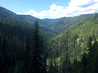
Continuing northeast from Grangeville, ID on Routes 13 and 12, I drove 126 miles of windy road along the even more scenic Middle Fork of the Clearwater River and then the Lochsa River. The Clearwater River is a beneficiary of the 1968 Act of Congress known as the National Wild and Scenic Rivers Act, which preventing the formation of a dam and allowed the Clearwater to flow unobstructed the way that it had for centuries. Because of how windy the road was, this section of my journey took many hours.
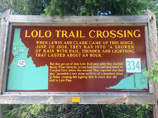
Finally, nearing the end of Route 12, the road rises steeply and abruptly from the riverbed to cross over the Bitterroot Mountains at Lolo Pass. This stretch of highway is also part of the Lewis and Clark Trail. In September of 1805, the Lewis & Clark Expedition encountered perhaps their most difficult stretch of terrain trying to cross the steep Bitterroot Mountains in the snow. Pummeled by a sudden thunderstorm and hail, they were forced to turn back. A week later, it was the Nez Perce who came to the aid of the starving Corps, feeding them, equipping them with horses, and guiding them over the Lolo Pass. Ironically, it was through this same pass that the non-treaty Nez Perce passed on their eastward journey to the Yellowstone region while being pursued by the US Army in 1877. Many of them perished when the Army caught up with them at the Big Hole Battlefield.
Descending on the eastern side of the Lolo Pass (without any brake light problems despite the very steep descent), I arrived in Missoula, MT. Here, I followed Routes 93 and 35 north for 44 miles along the eastern edge of the picturesque Flathead Lake until reaching my final destination--a Walmart parking lot in Kalispell, MT by 7 PM. Approximately 11 hours on the road to cover 419 miles of incredibly scenic countryside. Thus ends another day on the "Vanna Trail" across this great country of ours. Tomorrow--Glacier National Park.


No comments:
Post a Comment