Friday, May 31, 2024

Day 19: Temple of the Sun and Moon in Capitol Reef and a Quick Visit to Bryce Canyon NP

 Friday, May 31

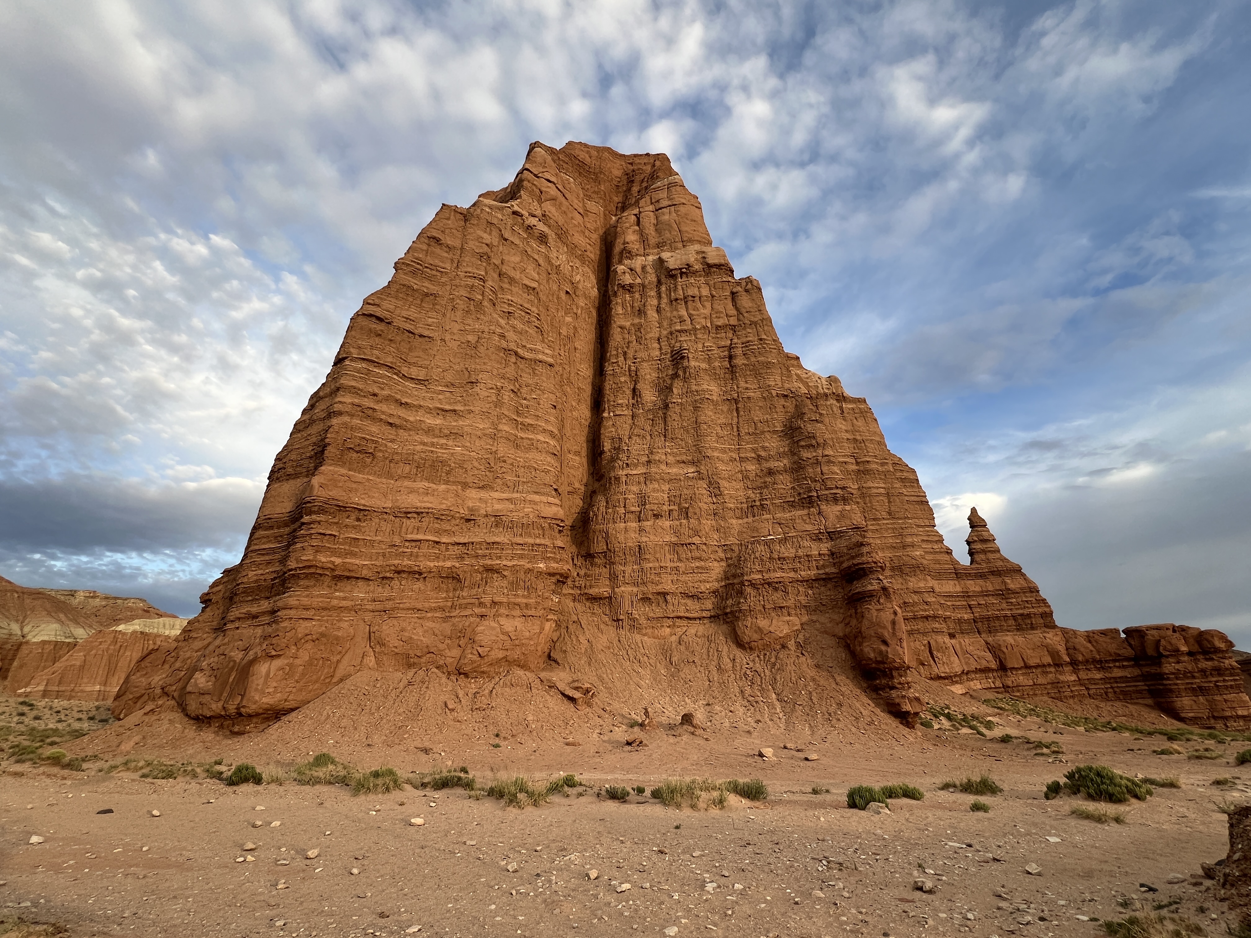
We got up at 3:45 AM and drove the short mile to the Wayne County Information Center where we met our guide Jason Willard from the Waterpocket Adventure Co. for a 4x4 tour of the Cathedral Valley loop of Capitol Reef national park. This part of the park is a 71-mile dirt and sandy road that is partly in the park and partly on BLM land. It is HIGHLY recommended to have a high-clearance four-wheel drive vehicle so you don't get stuck. At one point, there is also a water crossing. So we hired Jason to do the driving for us in his Ford Expedition. A four-hour tour cost us $390 total. We left the information center at 4:30 AM and headed toward the famous Cathedral of the Sun and Moon, two behemoth rock formations that are emblematic of the park. When we arrived, there was a group of five Asian photographers in a Toyota4Runner blocking the road, but they quickly left and we had the hilltop view to ourselves about 10 min before sunrise. We watched the mood change as the blue light of predawn with pink dabbles of light in the clouds changed into the brilliant orange of the sun on the sides of the rock formations. Absolutely picture perfect! 


Unfortunately, I was not feeling well at all. I was very car sick and light-headed. I had mistakenly taken a lisinopril (old BP med) on top of my usual BP meds thinking it was a Dramamine and my BP plummeted. I asked if he had any salty snacks and he offered me a Gatorade and then showed me a plant in the desert that was edible which literally tasted like salt (I think it was called saltgrass but I am unsure). This stabilized me a little. Jessica really liked the nearby Glass Mountain made of gypsum. Then we swung around to the other side of the Temple of the Moon for a different vantage point. 


After driving back to Rt 24 the way we came, we then entered the Cathedral Valley dirt road from the second side of the loop, crossing a small stream in the 4x4. This road was much more bumpy and sandy and we never could have made it ourselves in the van. Here, we stopped at the Bentonite Hills on BLM land and so I was allowed to fly the drone again. Then our tour was over and he returned us to Torrey, where I tipped him for the extra time and the help with my low BP. 


After getting a few groceries for breakfast and lunch at the very expensive ChuckWagon in Torrey, we drove two hours southwest to Bryce Canyon national park, where we rested and had a nice picnic lunch. Then we did some of the first few overlooks--short walks from the parking lot because my BP was still low at 100/67. These photos are from Sunset Point, Inspiration Point, and Bryce Point. This wasn't our first rodeo in Bryce, so we kept it short and sweet. 


Just a few miles outside the entrance to Bryce Canyon NP is the famous Ruby's, which has a hotel, campground, groceries, gas, etc. We got some more groceries here and tanked up on $4/gal gas. Then we drove back toward the park entrance. Only one mile before the entrance, there are plenty of lovely free dispersed camping sites in the Dixie national forest, where we set up camp and had dinner before hitting the bed early!


Thursday, May 30, 2024

Day 18 Bentonite Hills and Capitol Reef

 Thursday, May 30

We finally had a slow day! We slept in until 8:30. Once underway, we drove west of Hanksville UT on Rt 24 and then 3 miles back a sketchy dirt toad to the Mars Desert Research Station. Here we flew the drone trying to get some aerial photos of the Bentonite Hills. By coincidence, there was a massive college robotics competition there today of potential Mars rovers!


Next we drove 24 west to Capitol Reef NP, one of Utah’s “mighty five” national parks. Unfortunately, the scenic drive is closed all summer for repairs so there wasn't much to do. We had a nice picnic by the Fremont River and I made my Corona Arch YouTube video. 


Then we drove into the small but expensive town of Torrey and heard the news of the verdict in the Trump hush money case. After a plain rice dinner, it was off to bed early for our 4 AM wakeup tomorrow to see sunrise in the Cathedral Valley loop of Capitol Reef national park.

Wednesday, May 29, 2024

Day 17: Delicate Arch, Colorado NM, and Goblin Valley SP

Wednesday, May 29

We were awake at 4:06 so that we could drive into Arches NP and park at Wolfe Ranch for the steep 3.2 mile RT hike to Delicate Arch to watch the sunrise there. Someone got engaged under the arch around that time. I took my turn standing under the arch and climbed up Window Arch overlooking Delicate Arch. 


After the hike and cleaning up and washing up in the van after breakfast, we left Arches and drove to Colorado to Grand Junction. Here, we drove the Rim Rock Road through Colorado national monument. 


Back in the van and retracing our steps back to Utah, our next stop was at Goblin Valley state park, where I walked among the goblin structures and flew the drone and we showered at the campground there (ssh! campers only) before driving to Hanksville UT and boondocking on BLM land. 


Tuesday, May 28, 2024

Day 16: Moab and Arches

 Tuesday, May 28

Early morning for us with a 5:20 wake-up call so that we could drive into Arches National Park before 7 AM when timed permits are required. Added benefit is that the lighting is best in those early morning hours anyway. Check out these photos of Balanced Rock with the moon in the background, Turret Arch, and Double Arch. 


We spent all of the morning into early afternoon exploring this wonderful national park. Second, third, fourth, maybe even fifth slice of cheesecake—it just never gets old. Here are some pics of Skyline Arch, Broken Arch, Sand Dunes Arch, and the Fiery Furnace. 


After a lovely lunch at the picnic area for Lower Delicate Arch viewpoint, we drove south to Moab and then west on Rt274. About four miles out the road were some amazing petroglyph panels.


Ten miles out the road was the trailhead for Corona Arch, an arch that rivals the more famous Delicate Arch with an opening of 140 x 105 ft. Corona Arch, along with Bowtie Arch and Pinto Arch lie out this moderately strenuous 2.3-mi RT trail. Because they are on BLM land and not in the national park, I was able to fly my drone right up to and under the arch (YouTube coming soon…). 


There were also some great views of the Colorado River along Rt274 before we returned to our same free boondocking site north of Moab on Klondike Bluffs Road with four bars Verizon!


Days 51 and 52: Chicago and Indiana Dunes NP

 Tuesday, July 2 We had a shower! The little luxuries in life that home dwellers take for granted! Then we were off for a long day of drivin...